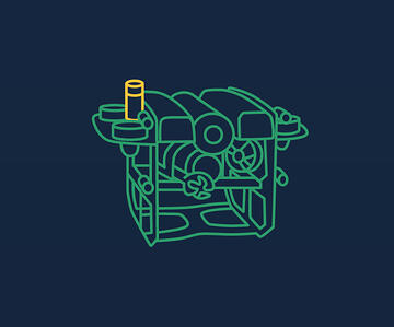
يمكن تسليم أجهزة الاستقبال الأربعة بأطوال كابلات تبلغ 10 أو 50 أو 100 متر. هذا يفتح أمامك خيارات نشر مرنة للغاية ، حتى على أكبر القوارب.
الإعداد الأمثل لجهاز الاستقبال
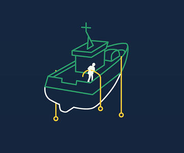
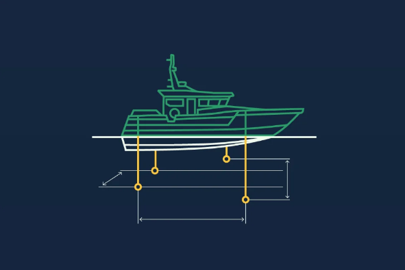
عندما يكون ذلك ممكنًا ، حاول نشر المستقبلات بحيث يكون لديك مسافة مترين على الأقل بينهما. قد يؤدي وضع أجهزة الاستقبال على أعماق مختلفة إلى زيادة الأداء.
تأكد من أن أجهزة الاستقبال مغمورة جيدًا ويفضل أن تكون أسفل منطقة الرش حيث قد تكون هنالك فقاعات هواء من الأمواج وما إلى ذلك.
تقييد إعداد جهاز الاستقبال
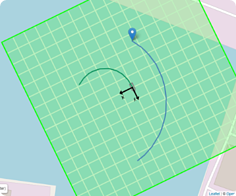
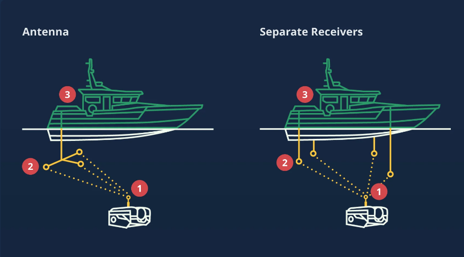
إذا كنت غير قادر على نشر خط أساس مربع ، فقد ينتهي بك الأمر ببعض القيود.
في المثال الموجود على اليسار ، جميع أجهزة الاستقبال في سطر واحد. مع مثل هذا الإعداد ، لا يمكن تحديد الجانب (أ أو ب) من خط الأساس الخاص بك. عليك قصر منطقة البحث في واجهة المستخدم الرسومية على جانب واحد فقط.
أداء
يتم تقدير فوائد UGPS حقًا عند العمل في أكثر البيئات صعوبة.
من خلال الجمع بين أجهزة الاستقبال المتعددة وخوارزميات البرامج المعقدة للغاية التي تعمل على الأجهزة الحديثة ، تتفوق UGPS حيث تتوقف أنظمة تحديد المواقع التقليدية عن العمل.
يتم عرض الأداء المذهل خاصة عندما تكون البيئة صعبة:
المياه الضحلة
داخل الخزانات أو حمامات السباحة
بالقرب من أجسام السفن
داخل أقفاص تربية الأسماك المأهولة بالكامل
القوالب الداخلية تحت سطح البحر
صحة
من خلال استخدام مبدأ الخط الأساسي القصير (SBL) ، يكون UGPS مستقرًا ودقيقًا ، ويضع محدد المواقع في نطاق متر واحد في نطاق 100 متر
اختبار أداء
يُظهر الفيديو أدناه اختبار أداء UGPS المثبت على قارب مزود بنظام تحديد المواقع العالمي (GPS) الذي يدعم RTK.
يوفر نظام RTK GPS تحديد المواقع بدقة تبلغ 1 سم تقريبًا للقارب ويسمح لنا بإنشاء سجل تعقب للقارب أثناء تنقله حول المرسى. لدينا بعد ذلك سجل تعقب لنظام تحديد المواقع العالمي (GPS) و UGPS.
من خلال تراكب سجل GPS مع سجل التتبع UGPS ، نوضح مدى موثوقية ودقة UGPS ، على الرغم من الصعوبات المرتبطة بتحديد المواقع الصوتية في المياه الضحلة (حوالي 6-8 م عمق).
The four receivers can be delivered with cable lengths of 10, 50 or 100 meter. This opens up for very flexible deployment options, even on the largest boats.
Optimal Receiver Setup
When possible, try to spread the Receivers out so you have at least 2 meters between them. Placing the receivers at different depths may increase performance.
Make sure the receivers are well submerged and preferably below the splash zone where there might be air bubbles from waves etc.
Limiting Receiver Setup
If you are unable to deploy a square baseline, you might end up with some limitiations.
In the example to the left, all receivers are on one line. With such a setup it is not possible to decide which side (A or B) of the baseline your locator is. You have to limit the search area in the GUI to only one of the sides.
Performance
The benefits of the UGPS are truly appreciated when working in the most challenging environments.
Combining the multiple receivers with extremely sophisticated software algorithms running on modern hardware, UGPS excels where traditional positioning systems stop working.
The amazing performance comes to display especially when the environment is challenging:
Shallow water
Inside tanks or pools
Close to ship hulls
Inside fully populated fish farming cages
Inside subsea templates
Accuracy
By utilizing a Short BaseLine (SBL) principle the UGPS is both stable and accurate, positioning the Locator to within 1 meter at 100 meter range
Performance Testing
The video below shows a performance test of the UGPS which is mounted to a boat that is fitted with an RTK enabled GPS.
The RTK GPS provides ~1cm accuracy positioning of the boat and allows us to generate a tracklog for the boat as it navigates around the marina. We then have a tracklog for the GPS and for the UGPS.
By overlaying the GPS tracklog with the UGPS tracklog we demonstrate how reliable and accurate the UGPS is, despite the difficulties associated with acoustic positioning in shallow water (~6-8m depth).
استكشف المزيد من العالم تحت سطح البحر بثقة تامة في بيانات تحديد المواقع التي تتلقاها باستخدام نظام تحديد المواقع تحت الماء. من خلال تقنية تحديد المواقع المطورة لهذا الغرض ، لم تعد الضوضاء غير المرغوب فيها تؤثر على دقة تحديد المواقع بالطريقة التقليدية مع حلول تحديد المواقع تحت الماء. تعرف على الفوائد وتعرف على المزيد حول نظام تحديد المواقع تحت الماء.
هوائي سريع الانتشار
مواصفات النطاق
كامل المواصفات واجهة المستخدم الرسومية
مبدأ التشغيل
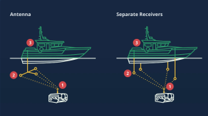
يمكنك الاختيار بين استخدام هوائي مضغوط أو أجهزة استقبال متصلة بكبلات منفصلة كخط أساس للاستقبال.
الهوائي سريع وسهل الإعداد في حين أن أجهزة الاستقبال المنفصلة ستمكّن خطوط الأساس المصممة بشكل مرن للغاية. كلاهما يدعم النطاق الكامل 300 متر.
محدد الموقع – ينقل محدد الموقع إشارة صوتية تلتقطها أجهزة الاستقبال.
خط الأساس – يلتقط الهوائي أو أجهزة الاستقبال المنفصلة الإشارة الصوتية من محدد المواقع.
الجزء العلوي – يستخدم كمبيوتر تحديد المواقع العلوي خوارزميات متقدمة لتثليث موقع محدد المواقع وحسابه بناءً على الإشارات المستلمة من الهوائي / أجهزة الاستقبال.
R100 أو R300
يأتي نظام Water Linked Underwater GPS بنسختين مختلفتين من النطاق ؛ R100 و R300 حيث يشير الرقم إلى أقصى مدى بالأمتار بين محدد المواقع والهوائي / أجهزة الاستقبال.
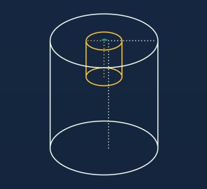
منطقة أسطوانية
منطقة التشغيل مصممة على شكل اسطوانة نصف قطرها 100/300 متر وبعمق 100/300 متر.
حد صعب
النطاق 100/300 متر هو “حد صعب” ، مما يعني أنه بمجرد تحرك محدد المواقع خارج هذا النطاق ، لن يتم حساب الموضع.
برنامج Acoustic +
النطاق محدود بالإشارة الصوتية من محدد المواقع والبرنامج الذي يعمل على كمبيوتر تحديد المواقع Master-D1.
المدى المحدد
يمكنك تقليل نصف قطر المكان الذي سيبحث فيه النظام عن محدد المواقع. هذه فكرة رائعة إذا كنت تعمل في مكان ضيق مثل خزانات المياه أو أحواض السباحة أو أقفاص الأسماك أو ما شابه ذلك. قد يمنحك تقليل النطاق حتى في المحيطات المفتوحة أداءً أفضل على مسافات قصيرة.
حدود المنطقة
يمكنك تحديد أي جزء من الأسطوانة تريد العمل بداخله. يجب القيام بذلك إذا كانت هناك عوائق مثل الأرض أو غيرها من الأماكن المحظورة لـ ROV الخاص بك. قد يمنحك تقليل المساحة حتى في المحيطات المفتوحة أداءً أفضل.
الحد من العمق؟
ليس من الممكن أو من الضروري تحديد العمق. تعتمد جميع أنظمة GPS تحت الماء على مستشعر ضغط منفصل لتوفير عمق محدد الموقع.
Explore more of the subsea world with full confidence in the positioning data you receive with the Underwater GPS. With our purpose-developed positioning technology, unwanted noise no longer affects positioning accuracy the way it traditionally has with underwater positioning solutions. See the benefits and learn more about Underwater GPS.
Quick deploy antenna
Range spec
Full featured GUI
Operating principle
You can choose between using a compact antenna or separate cabled receivers as your receiving baseline.
The antenna is quick and easy to set up while the separate receivers will enable very flexibly designed baselines. Both supports the full 300 meter range.
Locator – The Locator transmits an acoustic signal which are picked up by the Receivers.
Baseline – The antenna or separate Receivers picks up the acoustic signal from the Locator.
Topside – The topside positioning computer uses advanced algorithms to triangulate and calculate the position of the Locator based on the received signals from the antenna/receivers.
R100 or R300
The Water Linked Underwater GPS comes in two different range versions; R100 and R300 where the number indicates the maximum range in meters between the Locator and Antenna/Receivers.
Cylindric Area
The operational area is designed as a cylinder with a radius of 100/300 meters and a depth of 100/300 meters.
Hard Limit
The 100/300 meter range is a “hard limit”, meaning that once the Locator moves outside that range, the position will not be calculated.
Acoustic + Software
The range is limited by the acoustic signal from the Locator and the software running on the Master-D1 positioning computer.
Limiting Range
You can reduce the radius of where the system will search for the locator. This is a great idea if you are operating in a confined space like water tanks, pools, fish cages or similar. Reducing the range even in the open ocean may give you a better performance on short distances.
Limiting Area
You can limit which part of the cylinder you want to operate within. This should be done if there are obstacles like land or other no-go places for your ROV. Reducing the area even in the open ocean may give you a better performance.
Limiting Depth?
It is not possible or needed to limit the depth. All Underwater GPS systems relies on a separate pressure sensor to provide the depth of the locator.